
Longboat Key
Waterway Maintenance Program
Managed Canals and Waterways
Maintained depths between
to
3 |
to |
7' |
Serving the town by supporting:
Island Lifestyle
Recreation
Property Value
Emergency Services
Stormwater & Drainage
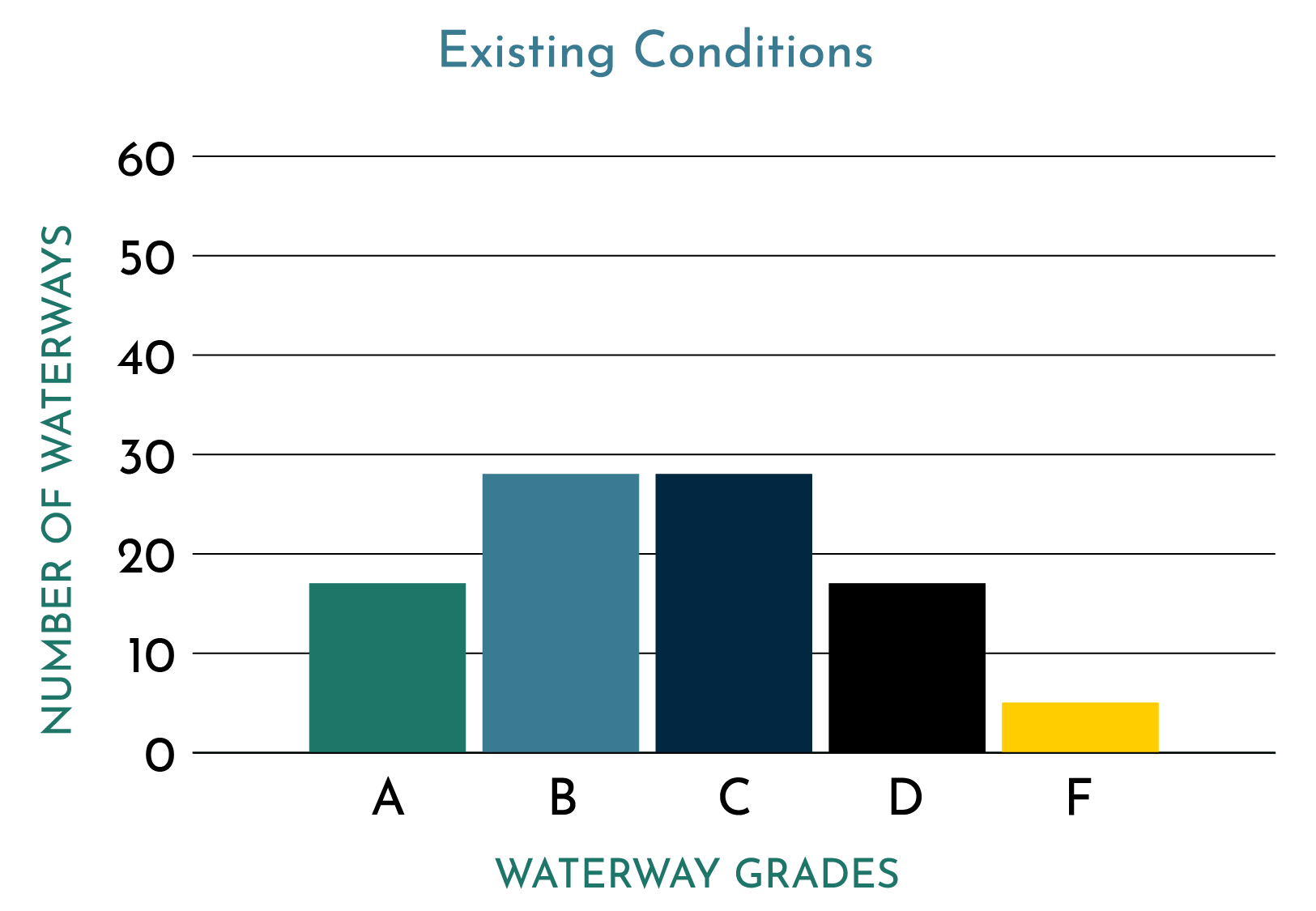
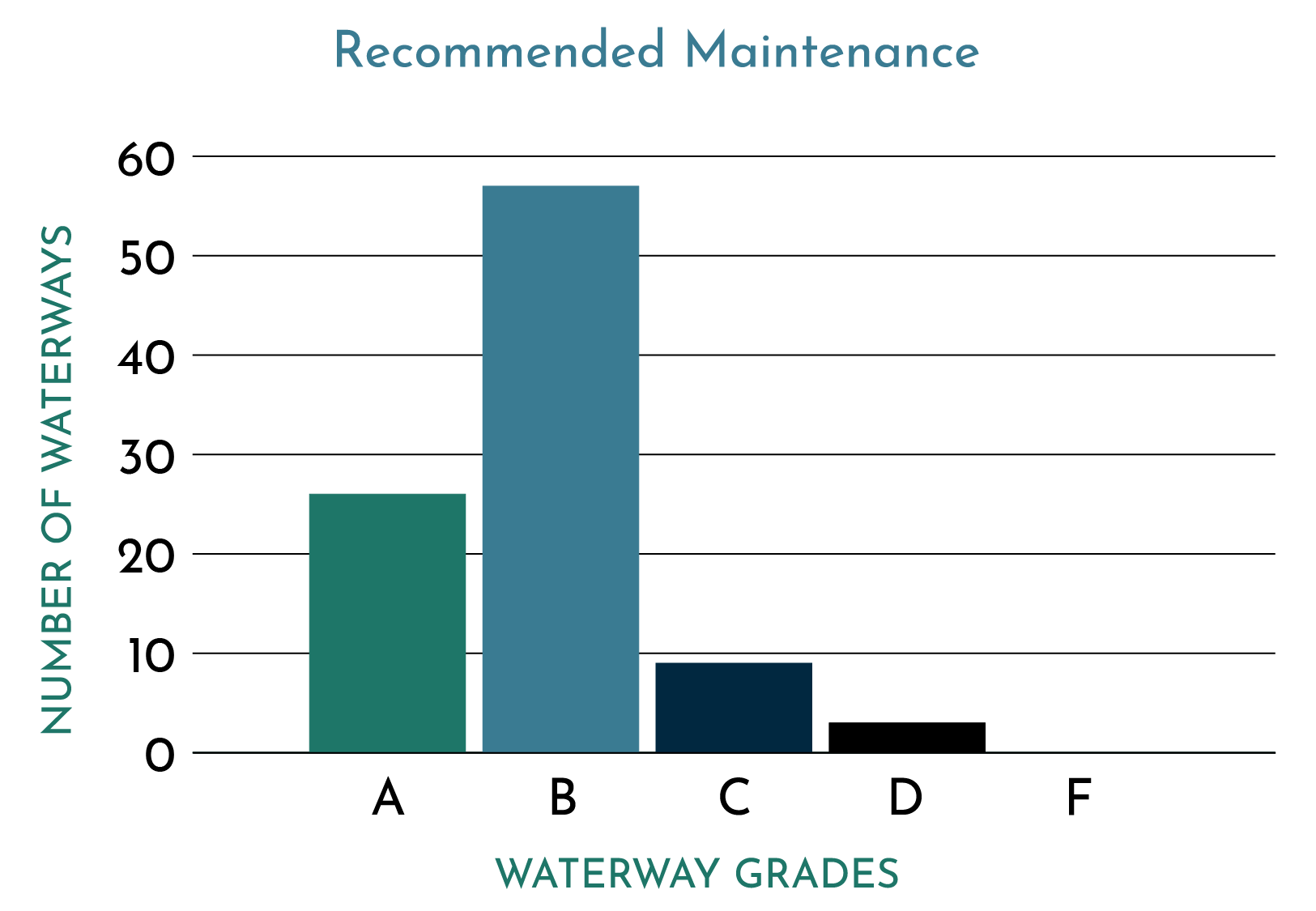
Waterway Conditions on Longboat Key
- Waterway intended use and vessel class
- Existing dimensions
- Exposure to natural elements (wind, waves, current)
- Existing impediments
- Limiting depth
- Overall navigability
Once evaluated individually, these factors were combined to yield a Letter Grade score for the existing condition of each waterway. A secondary set of scores were produced to visualize realistic outcomes if the recommended maintenance program were put in place. Use the toggle below to compare Longboat’s existing and proposed maintenance conditions:
Why Now
The proposed waterway maintenance program establishes a proactive approach to management of a critical and defining asset for the community.
Island-wide waterway maintenance on Longboat Key was first studied in 1996. The last canal dredging project was completed in 2001. Since then, the waterways have experienced years of natural shoaling, sedimentation and buildup of organic debris which restricts navigability, circulation and drainage. Like anything, long-term deferred maintenance compounds a problem.
Following years of discussion, Longboat Key leadership is now taking concrete steps to dredge and revitalize its aging canal systems. The program will begin with an initial restoration project to restore waterways to their intended form and function. Once restoration is complete, focus will shift to proactive maintenance and monitoring and the annual cost is expected to be reduced by approximately 50%.
Program Funding Details
Funding for the waterway program includes a combination of Valorem (value-based millage) and Non-Ad Valorem (Direct Assessment) tax. Each taxable parcel island wide will contribute to an Ad Valorem millage covering approximately 30% of the program costs. The remaining 70% of the program will be funded via Non-Ad Valorem special assessment by residents with direct waterway access from their property. Overall, approximately 80% of the program funding will be from direct access parcels and 20% of the program funding will be from non-direct access parcels. The program is expected to require approximately $2 million dollars annually for the first 5 years for initial waterway restoration. Once completed, the annual cost is expected to drop nearly 50% for continued proactive maintenance and monitoring.
Property Specific Details
More Program Information
Town of Longboat Key
|
Town of Longboat Key
|
Or by contacting the Town at: CanalDredging@longboatkey.org
Frequently Asked Questions
Does this mean my taxes will increase?
If the program is approved, property owners may see a separate line item on their tax bill related to the Navigation Maintenance Program. Financial details for estimated assessments can be found on the interactive map on the town GIS portal by searching or selecting a property.
When would the program begin?
Which waterways are included in the program?
Will this affect property values?
How can residents stay involved?
Residents are encouraged to attend meetings, review posted materials on www.longboatkey.org and provide feedback.
Where will additional information be posted?
What do I do if my information is incorrect or missing?
Will dredging affect seagrasses and environmental resources?
What happens to the material removed from the waterways?
Where does the shoaling come from?
How can I contribute to healthier waterways?
- Manage Yard Waste
Limit introduction of organic materials, like grass clippings, to storm drains and waterways. - Reduce Runoff
Cover bare patches of soil and aerate lawns for improved absorption. - Know When to Fertilize
Fertilizing during the rainy season (June – Sept) increases fertilizer loads into the waterways. - Keep it Tidy
Pick up after pets and keep trash and debris from entering storm drains.